Transportation drives development. Whether the river, railroad, streetcar, or automobile - land use follows transportation. Our current auto dependent pattern limits choices for many and requires unsustainable financial and environmental resources. A well designed, multi-modal transportation system combined with high quality mixed-use development offers a positive vision for a more sustainable future.
Transit Oriented Development (TOD) - walkable urbanism - serves a growing market and provides economic, environmental, and social benefits. Developing denser, mixed-use, walkable places within 1/4 mile of transit stations serves this market and creates significant real estate value.
This illustration shows three different programs and densities - in number of homes and square feet of retail/office/civic space - and translates them into incremental real estate value and potential new tax revenues to help finance multimodal transportation investments to create a fully integrated metropolitan system. An infrastructure bank, public land banking, equity participation, and other creative public/private financing approaches could provide additional financial resources.
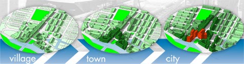

village
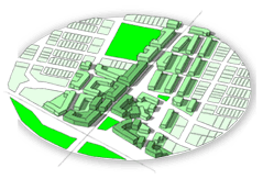
image design and illustration:
PETER MUSTY, LLC
|
The village scale residential is mostly 1-2 story single family/duplex homes and 2-3 story townhouses and flats with a small mixed-use core of 4-6 story buildings.
FAR: 1.0 - 3,282,000 sqft building area
Program:
- Market Rate Housing - 1,325 units
-
Affordable Housing - 325 units
- Retail - 420,000 sqft
- Office - 180,000 sqft
- Public/Civic - 180,000 sqft
- Parks/Open Space - 12.5 acres
Additional Property Value: $455,000,000
Total Bond Capacity: $19,000,000
|
Town
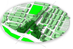
image design and illustration:
PETER MUSTY, LLC
|
The town scale has limited single family/duplex, mostly 2-3 story residential, and a denser core of 4-6 story with a few 8-10 story mixed-use buildings.
FAR: 2.5 - 8,200,000 sqft building area
Program:
- Market Rate Housing - 3,200 units
- Affordable Housing - 800 units
- Retail - 500,000 sqft
- Office - 1,500,000 sqft
- Public/Civic - 400,000 sqft
- Parks/Open Space - 12.5 acres
Additional Property Value:
$1,300,000,000
Total Bond Capacity: $54,000,000 |
City
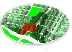
image design and illustration:
PETER MUSTY, LLC
|
The City scale has no single family, a
fairly equal mix of 2-3 story and 4-6
story residential, and a denser, core of
8-10 story with a few 15-20 story mixed-use buildings.
FAR: 4.0 - 13,000,000 sqft building area
Program:
- Market Rate Housing - 4,800 units
- Affordable Housing - 1,200 units
-
Retail - 650,000 sqft
-
Office - 4,500,000 sqft
-
Public/Civic - 1,500,000 sqft
-
Parks/Open Space - 15 acres
Additional Property Value:
$2,100,000,000
Total Bond Capacity: $90,000,000 |
Assumptions
1/4 mile radius is 125 acres, 60% of total land private/developable, 30% streets/ROW, sidewalks, bikeways, 10% parks, 1,200 sqft/unit, 80% efficient buildings Largest buildings at station transitioning to lower density moving out from station. All housing is mixed income, mixed ownership and rental. 20% of all units affordable to households at 60% of area median. FAR (Floor Area Ratio) is the number square feet of building compared to the area of land. Base FAR is .25 in all examples. Financial numbers assume capture 60% of total tax increment, 5.5% discount rate, 1.1% "blended" tax rate, 20 year term.
|
 |